Before anyone can say what a plot is worth, they need three other answers. Who owns the plot, and how much of it? Where exactly is it, and how big? What is on it today? Get one wrong and the value is wrong.
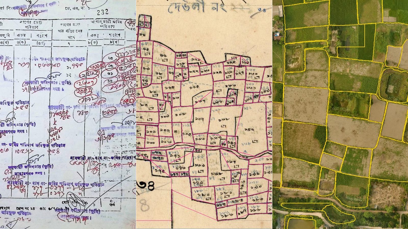
In Bangladesh, the answers live in three places: the khatian (খতিয়ান), or record of rights; the map of the mouza (মৌজা), the smallest revenue unit; and the ground itself. Online services now deliver copies of khatians and maps (BSS). But much of the archive behind them began as paper. By 2017, about 65 lakh (6.5 million) khatians and 18,500 map sheets had been scanned and indexed (The Daily Star), and a scan is only a picture of a page. The three answers have not been connected.
Why the answers matter more now
For years, the minimum value for registering land in Bangladesh has been the mouza rate. Rules made in 2010, and amended in 2015, say it should be reset every two years for each class of land in each mouza, from the average of registered sale deeds (Department of Registration). For nine plots in Dhaka compared by the Centre for Policy Dialogue (CPD) in 2023, the mouza rate averaged 29 percent of asking prices on property listing sites, though in a few rural or peripheral areas it is above the market price (CPD).
In June 2025 the government announced plans to bring minimum values in line with market prices. Under the proposed method, values would be set after investigation and public hearings, could not fall below the two-year average of all deeds for a land category, and a mouza could be split into clusters where prices inside it differ (The Business Standard). By June 2026 it was still being worked out: the finance minister said a committee had been formed and a nationwide survey was needed (Dhaka Tribune). Our post on the 2025 valuation rules has the detail.
Whatever form the change takes, a value built from deeds is only as good as the records behind them. Under the Acquisition and Requisition of Immovable Property Act 2017, compensation already starts from the average price, over the 12 months before the notice, of same-class land with equal facilities in the vicinity (section 9). New rules under the Act, issued in July 2026, ask all three questions: every owner’s rights, plot by plot, from the latest survey record; comparable sales from within 500 yards; and, before the notice, a digital survey with video and photos taken by drone or other modern technology, recording each plot’s actual class (Acquisition and Requisition of Immovable Property Rules 2026).
Who owns the plot, and how much of it?
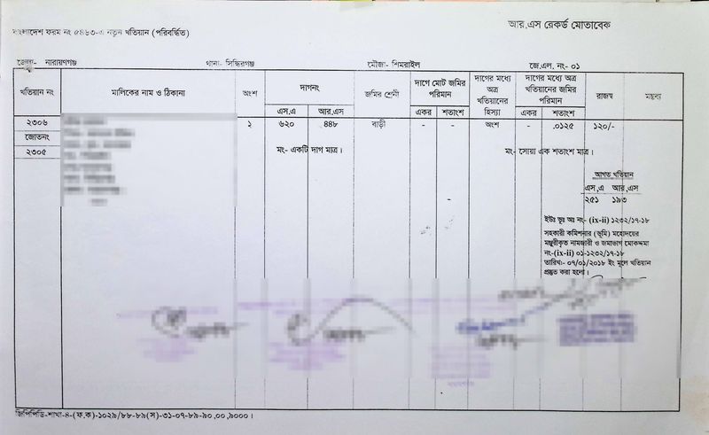
The answer lives in the khatian. Each khatian belongs to a mouza and lists the owners, each owner’s share, the plot (dag) numbers they hold, the class of each plot and its area. When land changes hands, the record is updated through mutation (namjari, নামজারি), and older khatians are often needed to show a chain of ownership.
The share matters as much as the name. Four heirs holding a 40-decimal plot equally hold 10 decimals’ worth each (a decimal, or শতাংশ, is a hundredth of an acre), and if one heir sells or mortgages, the buyer or lender takes only that heir’s share (Transfer of Property Act 1882, section 44).
The pages are hard to read and harder to search. Many are faded or torn, with decades of mutation notes handwritten over the printed table, and finding every khatian for a plot can mean pulling volumes off a shelf.
Our khatian model reads a scanned page as a trained data-entry operator would: the khatian number, mouza and upazila (sub-district), each owner and their share, every plot number, the class of land and the area. On 200 khatians per test, from two collections, all from mouzas it never saw during development, it scored 91 out of 100 on the index fields (khatian number, plots, mouza, upazila) and 93 out of 100 on the full record (owners, shares, plots, areas). The best general-purpose AI model we tested on the same pages scored 16 and 34. Some pages are too damaged for anyone to read, and some handwriting is ambiguous even to a clerk, so every record goes to a reviewer and, by default, a second person approves it (more on the khatian model).
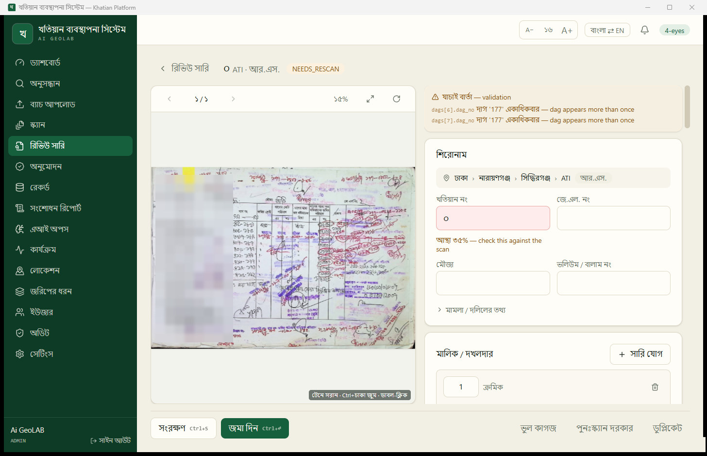
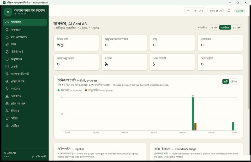
Once checked and approved in our Khatian Platform, khatians can be searched by khatian number, plot number or owner name, across eight kinds of record, from the older surveys to mutation khatians. A valuer can see who holds what share before relying on a deed, and a bank can check the record behind a mortgage without sending anyone to the record room (more on checking collateral).
Where exactly is it, and how big?
A khatian says plot 448, but not where plot 448 is, what shape it has or what lies next to it. That answer lives on the mouza map, drawn by the same survey, with a handwritten number inside every plot. Most sheets in use were drawn decades ago, many in the 1960s.
Where a plot sits inside its mouza matters. In 2025 a finance ministry official said Gulshan Avenue land in Dhaka is worth several times Madani Avenue land in the same mouza, yet Gulshan Avenue deeds often use the Madani Avenue value to show a lower price (The Business Standard). On paper, a map is hard to measure or search, and digitising it usually means tracing every line by hand.
Our mouza map model turns a scanned sheet into digital plot outlines, placed on the ground in their real position, each with the plot number it read. On 22 sheets it had never seen, with 7,216 plots between them, it found 95 percent of the plots, and found and read the correct number for 81 percent of all plots. Results are uneven: more than nine plots in ten right on the best sheets, fewer than four in ten on the faded, heavily marked worst. A reviewer confirms or corrects every plot (more on the map model).
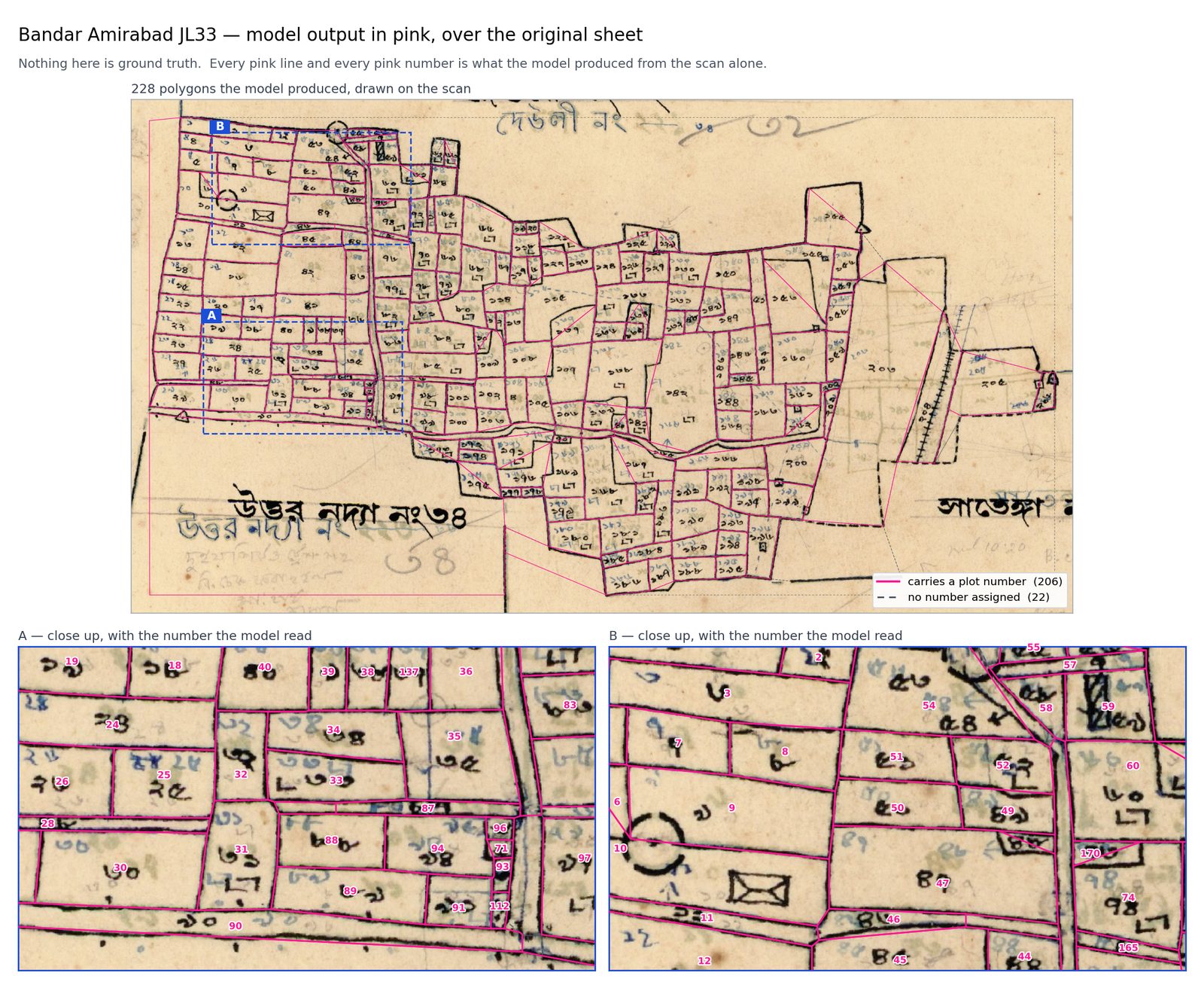
With the map digital, a valuer can check a deed’s area against the plot as drawn, see whether it touches a road or a river and find comparable plots next door rather than across the mouza. Marking out a 500-yard vicinity needs a map, and so would drawing any price cluster inside a mouza. When the government acquires land for a road or an economic zone, the plots on the route can be listed directly.
What is on it today?
The khatian and the map describe the land on the day it was surveyed. Since then, plots have been divided among heirs, ponds dug and ground raised for houses. Some changes reach the record room as mutations. Many do not, or arrive years later. So the class on record can say paddy where the ground holds a homestead, and homestead land does not sell for the price of low-lying paddy. Checking usually means sending someone to walk the land.
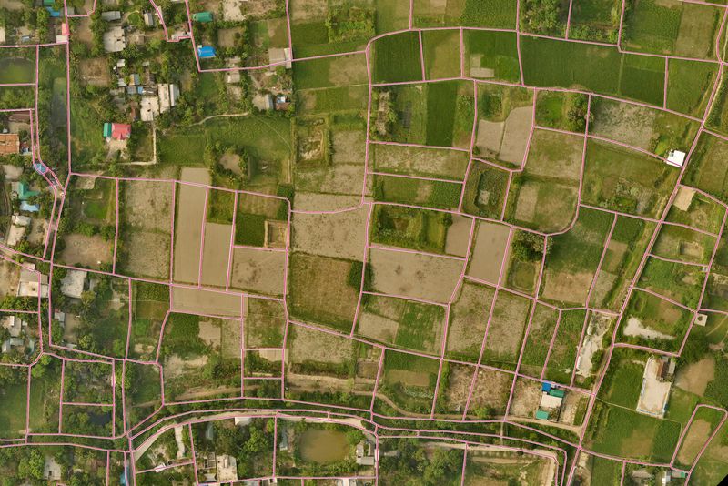
In 2025, a national aerial campaign photographed Bangladesh at 10 centimetres per pixel, detailed enough to show single houses and ponds. Our imagery model outlines every distinct piece of land it can see, mostly paddy fields, plus ponds, yards and homestead plots. It does not decide who owns anything. It shows what is on the ground. On test areas it had never seen, it found 79 percent of the single fields a person had traced, and 78 percent of the fields it drew matched a real field. Run unchanged over Narayanganj, a district it had never seen, it shows at least one field on the ground for about 78 percent of the rural plots on the mouza maps. It works poorly in towns, because it learned mostly from rural land. We shipped a rural-only version, told users where to trust it and are collecting more labels, including from towns (more on the imagery model).
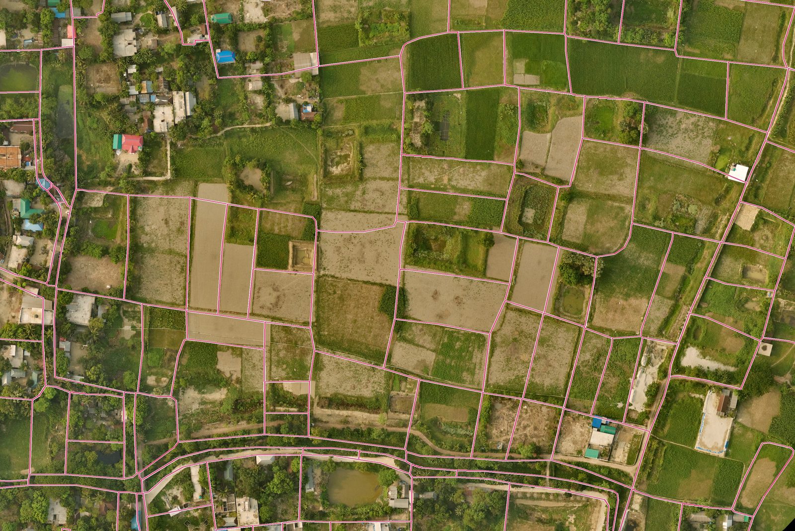
Rural sheets drawn in the 1960s, placed over the 2025 photos, land within about a metre of where the photo says they should, judged by eye. Where old lines and today’s fields disagree, the difference is information, not noise: it points to where the land has probably changed since the survey, for a person to check. A valuer can see the class on record beside the use on the ground. A bank can see whether the land behind a loan is what the papers say. A land office can find plots whose recorded class no longer matches what is there, before the next round of valuations.
All three on one screen
The Khatian Platform puts the three answers on one screen. Click a numbered plot on the mouza map, and it shows the active khatians that hold that plot in that mouza. Select a plot, and it can show the fields, ponds and homesteads the imagery model found there in the 2025 photo. It runs offline on one office computer, AI included, so no scan, record or map leaves the machine, and the AI never publishes anything on its own.
The platform does not set a price, and we do not offer automated valuation or price predictions. Judging value stays with valuers, lenders and the committees that set official values. We offer what that judgement rests on: a record a person has checked, a plot placed where it really is and a recent picture of what stands on it. We believe fair values start there.
If you value, lend against or manage land in Bangladesh and would like a demonstration, get in touch.
Related posts